NASA spots giant ocean swell that could signal El Niño’s return
- Date:
- June 15, 2026
- Source:
- NASA's Jet Propulsion Laboratory
- Summary:
- NASA satellites have detected a vast pulse of warm water reaching the coast of South America, signaling that El Niño is likely developing. The warm water is being carried eastward by massive ocean waves known as Kelvin waves, which also cause sea levels to rise. El Niño can reshape weather patterns worldwide, bringing floods, droughts, and temperature extremes.
- Share:
NASA and its European partners are tracking a major buildup of warm water in the Pacific Ocean that could signal the arrival of El Niño later this year.
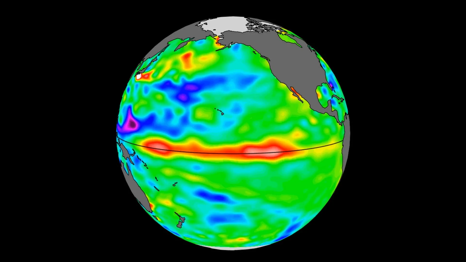
Data collected by the Sentinel-6 Michael Freilich satellite shows a broad area of unusually warm water, stretching hundreds of miles across, has reached the waters off South America. Because water expands as it warms, rising sea levels in a specific region of the ocean can reveal where temperatures are increasing beneath the surface.
El Niño can have far-reaching effects, bringing excessive rainfall to some regions while leaving others unusually dry. Those shifts can affect agriculture, transportation, water resources, and economies around the world.
Satellite Data Reveals Warm Pacific Waters
Launched in 2020 by NASA and led by ESA (European Space Agency) for the E.U. Copernicus Programme, Sentinel-6 Michael Freilich measures sea surface height across the world's oceans every 10 days with precision down to fractions of an inch. One of its key roles is monitoring warm ocean features known as Kelvin waves, which are closely linked to the development of El Niño.
Kelvin waves typically begin when wind patterns over the far western equatorial Pacific briefly reverse direction. Instead of the usual easterly winds that blow from east to west, westerly winds develop. Combined with a broader weakening of easterly winds along the equator, this allows tropical waters in the western Pacific to warm and sea levels to rise.
The resulting wave of warm water then travels eastward across the Pacific over several weeks. When it reaches South America, ocean temperatures and sea levels near the coast increase. El Niño forms when several of these Kelvin waves occur over a period of months, causing warm water to accumulate along the coasts of Colombia, Ecuador, and Peru.
"While this year's event started a bit later than the big El Niños of 2015 and 1997, it's beginning to catch up," said Josh Willis, a sea level researcher at NASA's Jet Propulsion Laboratory in Southern California and project scientist for Sentinel-6 Michael Freilich. "We'll see how big it gets."
Satellite observations showed a small Kelvin wave developing near Micronesia in late January before fading by mid-February. Another wave formed in early March and steadily moved eastward. By mid-May, sea levels near Peru were more than 5.9 inches (15 centimeters) above long-term averages.
"NASA's observation of El Niño uses sea level satellites like Sentinel-6 Michael Freilich to track massive Kelvin waves as they cross the Pacific, capture changes in Earth's ocean thermodynamics, improve forecasts of weather extremes, and help communities prepare for potential coastal hazards," said Nadya Vinogradova Shiffer, lead program scientist at NASA Headquarters in Washington. "Stay tuned as more ocean stories continue to unfold."
How El Niño Affects Global Weather
The term El Niño dates back to the 1600s, when fishermen noticed that warmer ocean conditions often became stronger around Christmas. They called the phenomenon El Niño, Spanish for "the boy," in reference to the birth of baby Jesus. The warmer waters also reduced fish catches.
When sea surface temperatures rise in the central and eastern Pacific, they can alter atmospheric circulation around the globe. One important effect is a shift in the jet stream, which influences the paths of storms. As a result, some regions may experience heavier rain or snowfall, while others see unusually hot and dry conditions.
The geographic reach of those impacts depends largely on the strength of the event. More moderate El Niños, such as those that began in 2018 and 2023, produced drought and flooding primarily within and around the tropical Pacific region. Stronger events, including the 2015-2016 El Niño, had consequences much farther afield, contributing to drought in Africa and flooding in California.
El Niño events typically reach their peak between November and January, meaning it will take several more months before the full extent of this year's impacts becomes apparent.
"Every El Niño is different," said JPL sea level researcher Severine Fournier, deputy project scientist for Sentinel-6 Michael Freilich. "But they almost always make for a hot year and big changes in rainfall in parts of the globe."
Sentinel-6 Continues Decades of Sea Level Monitoring
Sentinel-6 Michael Freilich currently serves as the official reference satellite for measuring global sea levels. The mission continues a record that began in 1992 with the launch of TOPEX/Poseidon. Since then, a succession of satellites has extended that long-term dataset. The newest satellite in the series, Sentinel-6B, launched in November 2025 and is expected to assume responsibility for the mission by the end of 2026.
More About Sentinel-6 Michael Freilich
Named in honor of former NASA Earth Science Division Director Michael Freilich, Sentinel-6 Michael Freilich is one of two satellites that make up the Copernicus Sentinel-6/Jason-CS (Continuity of Service) mission.
Sentinel-6/Jason-CS is part of the European Union's Copernicus Earth observation programme. The mission was jointly developed by ESA, the European Organisation for the Exploitation of Meteorological Satellites (EUMETSAT), NASA, and the National Oceanic and Atmospheric Administration (NOAA). Funding support came from the European Commission, while the French space agency CNES (Centre National d'Études Spatiales) provided technical support related to mission performance.
EUMETSAT operates and monitors the spacecraft and processes all altimeter science data on behalf of the European Union's Copernicus Programme, working in collaboration with the mission's partner agencies.
NASA's Jet Propulsion Laboratory (JPL), a division of Caltech in Pasadena, contributed three scientific instruments for each Sentinel-6 satellite: the Advanced Microwave Radiometer, the Global Navigation Satellite System -- Radio Occultation, and the Laser Retroreflector Array.
NASA also provided launch services, ground systems used to operate the NASA instruments, science data processing systems for two of those instruments, and support for U.S. members of the international Ocean Surface Topography Science Team.
Story Source:
Materials provided by NASA's Jet Propulsion Laboratory. Note: Content may be edited for style and length.
Cite This Page: